... Warooka Home Page ...

Genealogy
Warooka Cemetery Index Website
Births RootsWeb's WorldConnect Project
Marriages RootsWeb's WorldConnect Project
Deaths RootsWeb's WorldConnect Project
Births, Deaths and Marriages Genealogy SA
Births, Deaths and Marriages Trove Family Notices
Moorowie Hundred Map Website
Moorowie Hundred Map State Library of SA
Land Purchases by Credit Selection FamilyHistorySA
Books about Warooka
Back-to-Warooka celebrations, March 22nd to 26th, 1939. Warooka School Committee
A history of the Warooka Methodist Church Cemetery, 1873-1953 / Christina Ball (2008)
Blessed Brigid / Yorke Peninsula Writers Group (1995)
Murdock family tree by Maureen Filmer
Warooka Primary School 1879-1979 centenary: "Mallee Fowl" (1979)
West of the Peesey - Warooka, Corny Point, Stenhouse Bay Baker, J., Cant, M. & Murdoch, B. (1976)
Souvenir booklet to commemorate the 75th year of local government in the Warooka District (1963)
District Council of Yorke Peninsula - History of Warooka
The township of Warooka nestles on a low range of hills known as the Peesey Range.
The locality was originally known as Mt Hardwicke after the bay which lies to the north*.
*West of the Peesey. Page 6.
The township was settled in 1876 and the aboriginal name is said to mean "Muddy Water-hole."*
*West of the Peesey. Page 7.
Entrance to Warooka from Yorketown, showing Institute.
In the early days farmers of the locality found that even though the pastures were luch, their sheep lost condition and lambs lost control of their limbs*. It was noticed that the samecondition prevailed in the South East of Australia, Kangaroo Island and the South Western District of Victoria. In 1876 it was believed to be due to vapours arising from mangrove swamps and was called the Coast Disease**. However, in the late 1920's it was discovered the disease was due to deficiencies in the soil of minerals such as cobalt, copper and manganese. These minerals, although not required to make pastures grow, were absorbed by plant life and passed on to the sheep. The problem for this area was overcome by adding manganese to the superphosphate when topdressing the pastures***. *"The Weekly Times". Farmers Handbook. Page 64. **West of the Peesey. Page 1. ***West of the Peesey Page 64
On September the 19th, 1902, Warooka was shaken by a very severe earthquake, Sir Charles Todd, who was Government Astronomer at the time, calculated the epicentre to be at Warooka. Mr GF Dodwell, employed at the Government Meteorological Bureau, estimated the epicentre to be near Troubridge Island where the lighthouse was severely damaged in the same earthquake. However, as there is a geological fault which extends from Warooka into St Vincent Gulf, and passing near Troubridge Island, it would appear the whole area was subject to the same shock wave. The shock was severe enough to stop the Glenelg Town Hall clock and was felt down in the south east of South Australia and to the north as far as Orroroo*. *The Geology of Yorke Peninsula
The earthquake, which lasted three minutes, caused the brick chimneys of the hotel to collapse and at least two houses were severely damaged*. *West of the Peesey. Page 94
A great many Irish people settled in this area and in 1876 the foundation stone of the first Catholic Church, St Brigid's, was laid.
In 1877 James McCabe, a mason, built the Warooka Hotel*. *West of the Peesey. Page 9
Warooka is thought to mean 'muddy waterhole.' The site of the township of Warooka was originally farmland owned by Nicholas Player jr. A township sprang up here amongst the pastoral properties in the 1870s, with a post office in existence from 1874. By 1885 the town had a population of 400. A Methodist Church was opened in 1874, and this housed the public school from 1879 until 1882.
A jetty at nearby Point Turton was petitioned for in 1874, and when completed in October 1877 was just over 90 metres long. It was needed for the export of the locally grown grain, as well as the convenient shipping of goods for Warooka.
The Norwegian barque Ethel was stranded at the bottom of Yorke Peninsula near Warooka during a ferocious storm in January 1904. The only life lost was that of a sailor Leonard Stenersen, who drowned while attempting to secure a line to the shore. The ship was successfully refloated in May, but almost immediately an unexpected gale blew up, washing the ship back onto the shore, and causing the hull to crack. The remains of the Ethel can still be seen today.


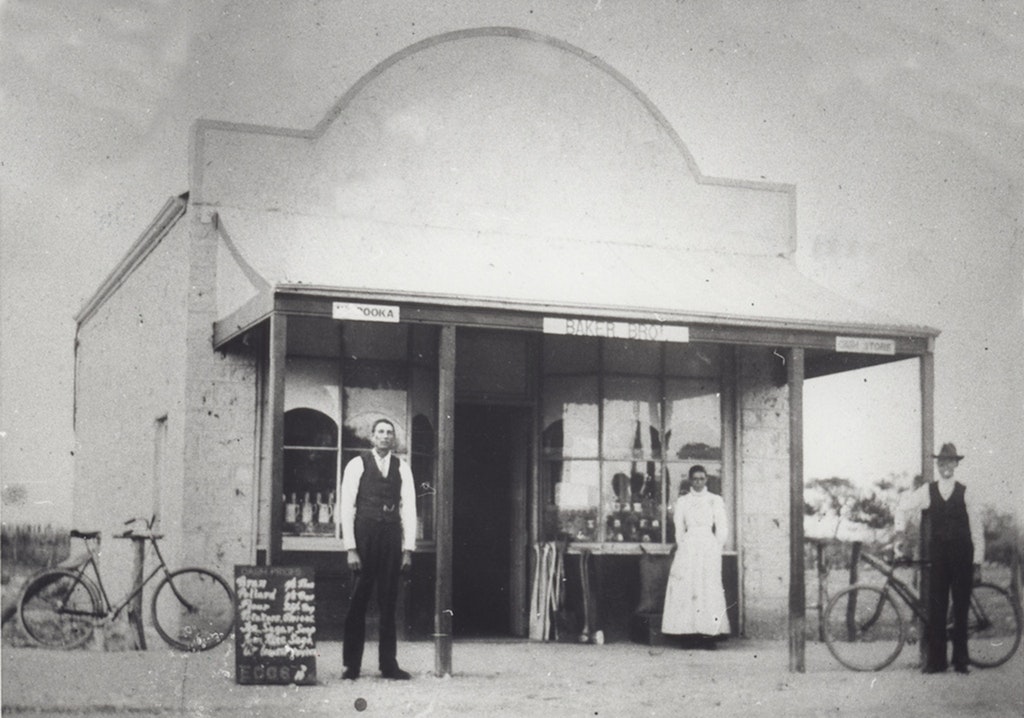
State Library of South Australia - B 32265 - Baker Bros. at Warooka 1910
[From a Special Correspondent.] Tue 29 Nov 1883
Leaving Yorketown I started for Warooka, a small but thriving township fifteen miles to the westward. The road is metalled nearly the whole way, and for about half the distance lies through land of fair quality. The farmhouses are for the most part good substantial buildings, and there is an appearance of permanence about them not seen in many districts. A peculiar feature of the country about here is the great number of salt lakes. I saw dozens of them. They vary in size from half an acre to upwards of two hundred acres. They are all shallow, none of them being more than about a couple of feet deep, and in summer time, when the water has evaporated the beds of the lakes are covered with a deposit of salt and gypsum which can be easily utilised for commercial purposes. A singular thing about these lakes is the fact that almost invariably the western banks are comparatively steep and broken, while those on the east are flat and shallow. They cover an aggregate of thousands of acres, and although in most cases the land is cultivated to their very edge they can be put to little practical use. Before reaching Warooka the traveller by making a short detour can pass through Moorowie station. This is the property of Mr. William Fowler, of Yarroo, Kulpara, and was for many years his residence. The homestead has been long occupied by Mr. Geo. Phillips, the manager of the station, During last winter some new ground on this station was broken up, ploughed, and sown, and the crop was looking splendid, and far better than anything I saw during the whole of my trip. Mr. Phillips expects to reap at least twenty bushels an acre, and rather more than this may be obtained from the best of the ground. The extent of this good soil is, however, limited, and the average of the whole 500 acres sown will probably be about fifteen bushels. The whole country about here when I saw it was well grassed, and all kinds of farm and station stock were looking in first-rate condition. Between Moorowie and Warooka lies the "Big Swamp." This is a flat miserable piece of country, about four miles wide from east to west and six miles from north to south, of rough limestone formation, with patches of saltbush growing about. In winter it is said to be nearly all under water, and crossing it at that time of the year in the face of a gale of wind must be a treat. From the geological appearances there can scarcely be a doubt that at no very remote age what is now known as the "swamp" was simply a narrow strait between Hardwicke Bay on the north and Sturt Bay on the south, through which the sea found its way. All the land here is useless. Getting on to Warooka the aspect of the country changes wonderfully, and I again saw some capital wheat paddocks. The township is well situated on a ridge of the Peasey Ranges, commanding a very extensive view in every direction. There are a public-house, a store, post-office, two village blacksmiths, a State school, a good sized and handsome Roman Catholic Church, a small Wesleyan Chapel, and a police-station. The view of the surrounding country, with the sea, the shipping, and Point Turton jetty is picturesque. The Warookaites are justly proud of their city on the hill, and woe betide the unfortunate visitor who fails to appreciate and express his admiration of the place. A large portion of the farming and about here is the property of Mr. J. Day, of Edithburgh, and the crops about the township will not be less than from 10 to 12 bushels per acre. I saw some self-sown hay crops on the slope of the hill which reached a couple of tons per acre.
Proceeding by the south coast eastward for about twenty miles Tucockcowie in passed through a small station formerly owned by Mr. W. Gilbert, of Pewsey Vale, but now in the hands of Messrs. C. & J. Day, and Port Moorowie is reached. There is not much farming along the line of road. At Port Moorowie, and from there to Mount Melville, most of the ground is taken up, but the area of good land is extremely limited. The population is small, the farms are poor, and the paddocks are nearly all very dirty. Not more than five or six bushels will be reaped through most of the district, although three or four paddocks looked as if they would yield about eight bushels. There is a good jetty at Port Moorowie, which is used only for shipping wool and wheat. The village of Mount Melville has decayed considerably, and the little public school which was formerly conducted there has been closed.

State Library of South Australia - B 33389 - Warooka Bakery 1940

State Library of South Australia - B 26755 - View of Warooka 1926

State Library of South Australia - B 32092 - Memorial Hall, Warooka 1930

State Library of South Australia - B 32183 - Warooka Hotel after the earthquake 1902

State Library of South Australia - B 32186 - Warooka Methodist Church 1930

State Library of South Australia - B 32156 - Mr James Murdock's home at Warooka 1900

State Library of South Australia - B 32082 - Scrub rolling near Warooka 1910

State Library of South Australia - B 32196 - Team of eight drawing a cutti-packer 1910

State Library of South Australia - B 62599
WAROOKA: Four fishermen standing outside the local Warooka garage where they each hold a large crayfish caught at Pondalowie Bay near Warooka, South Australia 1930
A PIONEER'S STORY OF SOUTHERN YORKE PENINSULA by GEORGE THOM, WAROOKA
Fri 4 Sep 1943, The Pioneer (Yorketown, SA : 1898 - 1954)
FROM ABERDEEN TO ADELAIDE
IN some ways forty-four years seems a long stretch out of a man's life—but it all depends upon what
filled the days and months of those years! Sitting here in my homestead on southern Yorke Peninsula, inside my 900- acre block of country, I've been thinking with a pen in my hand.....
A PIONEER'S STORY OF SOUTHERN YORKE PENINSULA by GEORGE THOM, WAROOKA
Fri 11 Sep 1943, The Pioneer (Yorketown, SA : 1898 - 1954)
SOME NATIVE LEGENDS
My Experiences with aborigines of Southern Yorke Peninsula, and the tales that have come to me from many angles during my life in those parts, induce me to pass on to you some of the stories I've heard regarding these original inhabitants cf the country before the days of the white man....
A PIONEER'S STORY OF SOUTHERN YORKE PENINSULA by GEORGE THOM, WAROOKA
Fri 18 Sep 1843, The Pioneer (Yorketown, SA : 1898 - 1954)
CLASHES WITH KANGAROOS
My meeting in the bush with Mr. J. V. Davey, of "Honiton," as he was looking for his sheep in that
part of his country near Pondolowie Bay, led to him calling on me a few weeks later to offer me the job
of working manager of his property......
A PIONEER'S STORY OF SOUTHERN YORKE PENINSULA by GEORGE THOM, WAROOKA
Fri 25 Sep 1953, The Pioneer (Yorketown, SA : 1898 - 1954)
MUSTERING STORIES
Before the days of World War I, mustering on Southern Yorke Peninsula was a job that required a good dog. Here, in the fourth instalment of Mr. Thorn's story, are tales of a good dog, and more of his experiences in the scrub country.....
A PIONEER'S STORY OF SOUTHERN YORKE PENINSULA by GEORGE THOM, WAROOKA
Fri 2 Oct 1953, The Pioneer (Yorketown, SA : 1898 - 1954)
WAR, AND BACK HOME
To carry out my plan of joining the A.I.F. I left Swivel Hut, Marion Bay, on a Saturday morning in September of 1915, by buggy and pair, for Mr. J. V. Davey's homestead at Honiton, thence travelling on to
Edithburgh, where boarded the ship for Adelaide, arriving in the metropolis on Monday.....
A PIONEER'S STORY OF SOUTHERN YORKE PENINSULA by GEORGE THOM, WABOOKA
Fri 9 Oct 1953, The Pioneer (Yorketown, SA : 1898 - 1954)
THE FARM THAT WAS HOPELESS
Introduction of trace elements and their contribution to agricultural and livestock production is described in this, the final episode of Mr. George Thorn's story of early days on Southern Yorke Peninsula. The resultant harvest was amazing, the yield being eight bags an acre from the area on which the manganese-super mixture was drilled, whereas from the area on which only superphosphate had been used the yield was practically nil.......
WAROOKA.
Friday 7 December 1877, Express and Telegraph (Adelaide, SA : 1867 - 1922) Trove
Warooka, a small collection of buildings of a substantial character, including two chapels (Wesleyan and Roman Catholic), two or three stores, and a new hotel. There is to be a celebration at the opening of the latter about a fortnight hence, when Mr. Ward, M.P., is to be entertained at a public dinner. One of the wants of Warooka is a State School, as there are numerous families in the neighborhood, and there is no school nearer than Yorketown. Warooka has recently been declared a polling-place by the present Chief Secretary at the instance of Mr. Ward. The necessity for such a convenience can only he understood when it is stated that out of the whole population there only one vote was registered at the late election for the Legislative Council, because the electors had to cross the swamp to record their votes at Yorketown, and that vote was given for Mr. Morgan. There is no township beyond Warooka to the westward, nor to the south, but settlement is gradually spreading in both directions. Passing through Mr. J. Hannay's Orie Cowie Station, where the character of the country changes, fresh water lagoons take the place of salt ones, and the teatree and sheaoak become thicker, and the landscape more parklike and pleasing, we began the ascent of Para Wurlie Hill.

BIG FIRE NEAR WAROOKA.
On Sunday morning a fire started near white Hut Station, which is situated about 26 miles south-west of Warooka, and spread with alarming rapidity. It travelled through many square miles of country in the Hundred of Carribie, and hundreds of acres of feed, several miles of good fencing, and a few sheep were destroyed before it was conquered. It was not until Wednesday afternoon that the fire was well under control. On "Thursday morning the burning area was within a ring of firebreaks, and it was hoped would expend itself in the scrub country to which it had been confined by the herculean efforts of the firefighters. The fire, which was first noticed about 10.30am. on Sunday morning, started close to a hut occupied by a man named Thomas Wilson, a woodcutter, 62 years of age, who had been working at Cape Spencer and was making his way to Edithbugh. He tried to put it out, but being unable he completely lost his nerve, and, taking a knife, endeavored to cut his own throat. Fortunately, the wound was not serious. M.C. Hunt was called and brought the man to the Yorketown Hospital, where he is still an inmate. The fire spread to adjoining sections, and the volume of smoke soon attracted men from all quarters. The early firefighters, being few in number, had a strenuous time, and some of them remained on the scene Until Wednesday morning, fortunately, there were no farmhouses in the vicinity, but strong wind took the fire in close proximity to Mr. Faggoter's homestead in the Corny Point district, and only the strenuous efforts put forth by the men saved the property.
On Tuesday and Wednesday fully 250 men were fighting the fire. The reinforcements had come from Minlaton, Brentwood, Stansbury, Edithburgh, Yorketown, and the surrounding districts. Breaks were burnt all round the fire, which at one time was 10 miles to 12 miles wide. A break about a chain wide was burnt through Mr. Liddiard's barley stubble near Corney Point to prevent the fire spreading towards his homestead. ln and around the area some 7,000 sheep owned by various leaseholders were pastured. These were all moved to safer soots, but not until a few had been scorched. We have heard fictitious tales of thousands of sheep being burnt, scores of kangaroos hopping about the hot earth, and emus with flaming plumes spreading the fire wherever they ambled, stables and haystacks burnt, etc. The thanks of the firefighters are due to those and women who provided eatables, drinking water, and other liquid refreshments. The fire passed through the properties of Mr. Koennecke. A. P. Anderson, B. Mumford, S. Vigar. C. Hayes, Hill's Hut, Alf. Barrett, W. Cad, Geo. Liddiard, Algie, Faggotter, and Baker, all of whom have been put to great inconvenience and loss.
A fire at Marion Bay during the week was alleged to have been caused by a spark from the locomotive. The men employed at the Works turned out in full fore and conquered the fiend. Help was also rendered by the men from the Cape Spencer Works.
On Thursday evening word reached Yorketown that another fire had started near Carribie Station, in the Hundred of Warrenben.
Series Id: GRG18/222 - State Records of South Australia
Warooka School Records Consignment/Sub-Series: 00001 Admission registers - Warrooka School
Access: Open Total Units: 5 Description: 5 volumes. 1883-1965. Use microfiche in Research Centres.
Below is a list of Records in this Consignment. Scroll through the list or use the "Go To" box to get to the required Unit.
Click on the Unit ID or Item links to get further details about the available Units and Items and/or to order them.
Unit Id Item Date Range Description 1 Description 2 Description 3 Description 4 Description 5
1 1879 - 1899 - Item Jun 16 1879 - Mar 20 1899 Boys & girls 0.010 X 0.380 X 0.270
2 1899 - 1937 - Item Apr 17 1899 - Sep 27 1937 Boys & girls 0.010 X 0.450 X 0.280
3 1937 - 1949 - Item Sep 27 1937 - Feb 8 1949 Boys & girls 0.005 X 0.430 X 0.260
4 1949 - 1957 - Item Feb 8 1949 - Jul 15 1957 Boys & girls 0.005 X 0.440 X 0.280
5 1958 - 1965 - Item Feb 11 1958 - Feb 9 1965 Boys & girls 0.005 X 0.440 X 0.270
GA1427 - State Records of South Australia
Warooka Primary School Date Range: 1879 - ct Inventory of Series Description
Warooka is a township situated on the southern part of the Yorke Peninsula. It is located approximately 225 kilometres from Adelaide by road.
Correspondence directed to the Council of Education in 1878 resulted in a school to be commenced in Warooka (1). Warooka School opened in in 1879 with 31 students being taught in the Hardwicke Bay School Chapel. Eliza Parkins was the school's first teacher (2).
In 1882, the still surviving stone classroom was built. The following year, Warooka School was classified as a public school (3).
A residence for the head teacher was built in 1935 (4).
After 1950, the school added one double and two single classroom blocks in response to a rise in enrolments (5).
As of 2010, Warooka Primary School educates children from Pre-school to Year 7 (6).
Contents Date Range Series Date Range Number of Units Public Access Series Id Series Title
1965 - 2000 1965 - 2000 1 Part Open GRS/9512 Admission registers - Warooka Primary School